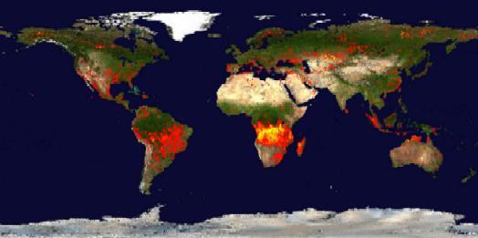
 NASA has recently provided us with its latest composite look at fires around the world detected by a pair of remote-sensing satellites during their orbits around the earth in the first 10 days of July. As you could probably figure out, the red dots mean a few fires, while the yellow dots mean a lot of fires. It's a pretty dramatic picture (probably too dramatic) at how forests and grasslands around the world--particularly in the tropics--are literally ablaze. Fire undoubtedly remains humanity's oldest and most powerful tool for transforming landscapes and ecosystems, a tool that is all the more powerful because it is a natural phenomenon that we've only partly domesticated.
Thursday, July 21, 2005
NASA's World Fire Map
NASA has recently provided us with its latest composite look at fires around the world detected by a pair of remote-sensing satellites during their orbits around the earth in the first 10 days of July. As you could probably figure out, the red dots mean a few fires, while the yellow dots mean a lot of fires. It's a pretty dramatic picture (probably too dramatic) at how forests and grasslands around the world--particularly in the tropics--are literally ablaze. Fire undoubtedly remains humanity's oldest and most powerful tool for transforming landscapes and ecosystems, a tool that is all the more powerful because it is a natural phenomenon that we've only partly domesticated.
Subscribe to:
Post Comments (Atom)

No comments:
Post a Comment